CDD
Research Scientist / Produce and interpret high-resolution maps of forest attributes
Contexte
Produce and interpret high-resolution maps of forest attributes in Central African rainforests using satellite imagery, LiDAR, ground inventories and AI
The One Forest Vision Initiative is a new research programme between African countries and France launched in 2023 with a duration of five years, aiming to monitor changes of central african rainforests for height, biomass and diversity, in order to better understand the impacts of climate change and anthropogenic pressure on these diverse and important ecosystems, and provide science-based knowledge to protect and restore forests in the region.
The development of satellite imagery and LiDAR, combined with recent progress in AI, are disrupting the way forests are being monitored. While forests are in particular essential for carbon sequestration and biodiversity, they are profoundly affected by climate change, degradation and deforestation. Accurate and granular forest maps are essential for forest managers and public institutions in order to adapt management practices and policies.
The Research Pillar 3 of the One Forest Vision Programme has assembled an international team of established researchers in machine learning, remote sensing, forest ecology (Paris Laboratoire des Sciences du Climat et de l’Environnement, INRAE, IRD, CNRS and CIRAD) in order to produce accurate and periodically updated maps of forest structure (height), biomass carbon stocks, and activity data related to forest loss and gains (disturbances, including degradation, fires, clearcut) using cutting edge artificial intelligence models driven by satellite and new field observations collected by the GEOTREES project in collaboration with Dr. J. Chave from CNRS. The Paris team is collaborating with public institutions such as the AGEOS, the Space agency of Gabon.
The Paris team is looking for an experienced and motivated Research Scientist who will actively contribute to the production, validation, interpretation and publication of forest maps, with a focus on producing the best possible maps of biomass and biomass change and attributing observed changes to biotic, climatic and anthropogenic factors.
Description
- The missions will cover data processing , model design, training, inference, interpretation of results and publication in peer-reviewed journals.
- Apply and improve existing deep-learning models of forest attributes.
- Access and process satellite imagery and LiDAR using community tools developed by the lab (e.g., Sentinel 1 and 2, Gedi, LiDAR HD, Spot).
- Implement tools for inclusion of input data sources from multiple spaceborne and airborne platforms as input or validation of AI models (Alsar, Nisar, Icesat 2, orthophotos, airborne LiDAR) to improve the accuracy of monitoring of canopy height and biomass, and their changes over time.
Interact with data-scientists from Kayrros, a SME based in Paris who will help for running the models at large scale over the full central African biome. - Interpret the resulting maps of height and biomass changes using activity data such as degradation, deforestation features, and additional information on forest types, management, as well as climatic and soil drivers, by developing and using state of the art explainable machine learning and statistical models.
- Promote and diffuse the results of research results at scientific conferences, workshops organized with African countries as part of the One Forest Vision Initiative, and write research publications in collaboration with national and international experts. Several publications in high-profile journals are expected from the project.
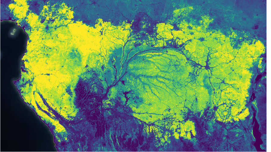
Map of forest height obtained with a U-net model, using GEDI, Sentinel 1 and Sentinel 2 (courtesy of Kayrros and LSCE)
More information
Location
Laboratoire des Sciences du Climat et de l’Environnement (Saclay, in the Orme des Merisiers green area). Remote friendly. LSCE is a world-class research laboratory established and a collaboration between CEA, CNRS and the University of Versailles Saint-Quentin (UVSQ). The LSCE hosts approximately 300 researchers, engineers and administrative staff including many PhD and master’s students. This project will provide the employee with the opportunity to work directly on advanced methods with researchers from the LSCE and other institutions.
Contract duration
24 months, with an extension possible
Starting date
The position is available from April 1st 2024 and will remain open until filled. The expected start of the position is June-July 2024.
Salary
Competitive salary, full social and health benefits, commensurate with work experience.
Supervision
- Main supervisor: Philippe Ciais. Research director at LSCE
- Co-supervisors: Ibrahim Fayad (LSCE), Fajwel Fogel (ENS), Martin Schwartz (LSCE)
How to apply
Applicants should submit a complete application package by email to the contacts below. The application package should include (1) a curriculum vitae including e.g. important recent publications / projects, (2) statement of motivation (3) answers to the selection criteria above (4) names, addresses, phone numbers, and email addresses of at least two references.
Contacts
Please send a CV, a motivation letter and the names of two reference persons
Reference
Schwartz, Martin, et al. « FORMS: Forest Multiple Source height, wood volume, and biomass maps in France at 10 to 30 m resolution based on Sentinel-1, Sentinel-2, and Global Ecosystem Dynamics Investigation (GEDI) data with a deep learning approach. » Earth System Science Data 15.11 (2023): 4927-4945.
Height maps with vision transformers in Ghana:
Fayad, Ibrahim, et al. « Vision Transformers, a new approach for high-resolution and large-scale mapping of canopy heights. » arXiv preprint arXiv:2304.11487 (2023).
GEDI: https://gedi.umd.edu
S1/S2 satellite imagery: https://sentinels.copern1icus.eu/web/sentinel/home
LiDAR HD: https://geoservices.ign.fr/lidarhd
Compétences requises
- You have a PhD in Remote Sensing / Forest monitoring / Machine Learning / Computer Science.
- You have experience in building and using ML models in the context of EO-based monitoring of forests and / or land surface properties.
- You have experience in remote sensing.
- You have a publication track record and ability to present scientific results to the scientific community, as well as to a diverse range of stakeholders and public audience.
- You like problem solving, you are autonomous, but want to work in a collaborative environment.
- You are able to lead and structure research projects.
- You are curious, enjoy learning and a research environment.
- You want to work on problems that can benefit the environment.