Fine-scale ocean-atmosphere coupling: influence on storms
While the role of medium-scale ocean structures in large ocean currents such as the Kuroshio in the intensification of storms is well established, the role of sub-mesoscale ocean fronts (~10-20 km) remains largely unknown. A Franco-American team, led by a researcher from CNRS Terre & Univers, has explored this question in a study published in Communications Earth & Environment.
Mid-latitude storms are influenced by moist convection processes in the atmosphere, generating clouds and precipitation. Westerly ocean currents, such as the Gulf Stream and the Kuroshio, play an essential role in bringing moisture to the atmosphere, thereby enhancing convective activity and storm intensity.
Although the influence of mesoscale oceanic structures (~200 km in size) is well understood, the influence of small submesoscale oceanic fronts (~10-20 km) remains poorly understood due to a lack of numerical models and high-resolution experimental data.
The study carried out over the winter of 2020-2021 revealed the significant impact of sub-mesoscale oceanic fronts on precipitation within winter storms and other meteorological phenomena, such as atmospheric rivers.
Global simulation on fine scales
The team used a global simulation coupling ocean and atmosphere (COAS) at kilometric resolution, itself composed of the atmospheric and terrestrial model of the Goddard Earth Observation System (GEOS) coupled with an ocean configuration of the MIT general circulation model (MITgcm). This configuration makes it possible to analyse ocean-atmosphere interactions at very fine spatial scales, particularly those linked to sub-mesoscale oceanic fronts.
The team was thus able to study the winter storms developing above the sub-mesoscale ocean fronts present in the Kuroshio extension (Fig.1).
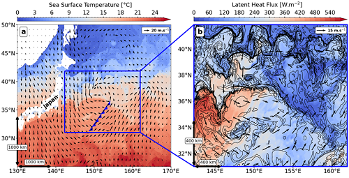
Image of a storm developing over the extension of the Kuroshio, a large ocean current comparable to the Gulf Stream. © Félix Vivant
In particular, they quantified the impact of different oceanic and atmospheric scales on water vapour fluxes at the air-sea interface (latent heat fluxes, see Fig. 1b), showing that these fluxes are linked to mesoscale (~40%) and submesoscale (<10%) oceanic movements.
Towards a better understanding of the hydrological cycle
The strong variations in sea surface temperature characteristic of sub-mesoscale oceanic fronts (~5°C per 10 km) generate a secondary atmospheric circulation extending up to 4km in altitude, increasing precipitation by up to 14mm per day in the warm sector of storms.
This study shows that sub-mesoscale oceanic fronts help pump moisture and heat from the ocean into the atmosphere, which can affect the intensification of storms and other meteorological phenomena, such as atmospheric rivers.
It highlights the importance of taking into account fine spatial and temporal scales to better understand the role of the coupled ocean-atmosphere system in the Earth’s hydrological cycle.

Phytoplankton bloom in the Kuroshio Current, eastern Japan. This MODIS satellite image shows eddies and narrow ocean fronts, visible as green bands between cloud-covered areas. © NASA Ocean Color
More
Laboratoire de météorologie dynamique (LMD- ECCE TERRA / CNRS / ENS-PSL / Ecole polytechnique / Sorbonne Université)
Reference
Ocean submesoscale fronts induce diabatic heating and convective precipitation within storms. Nature, Communications earth & environment, 2025.
Contact
Félix Vivant, PhD student ENS-PSL au Laboratoire météorologie dynamique (LMD-Ecce Terra) •