Cumulus Congestus
Developing on a vertical axis, these clouds are also known as towering cumulus. We are getting closer to a storm cloud, but not quite yet. Pack-up your bag and a good raincoat, adventure is on its way!

Cumulus congestus with a rainbow, oil pastel by Camille Risi from a photograph by Florentin Cayrouse, Météo-France
Specific features
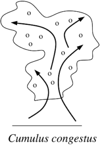
Bigger than its cousin the humilis, the congestus’s shape remind that of a cauliflower. Focused around an updraft of air, it grows in swirls, like smoke coming out of a chimney. It can reach 7000 metres high. White with a darker basis from afar, it looks dark grey from underneath.
Origin
Grows when the air close to the surface is hot and wet (see cumulus humilis). Compared to its cousin the humilis, congestus forms when the atmosphere is more unstable (for instance, hotter and wetter close to the surface), allowing the air to rise higher.
Evolution
Because they are bigger, congestus last longer when the dry air nibbles at them in altitude and can live up to an hour. They are the link between humilis and greater storm clouds. As it dissolves into the atmosphere, every cloud makes the air a little bit wetter. That way, every “dead cloud” leaves a stream of humidity that will make it easier for the next one. This dance of the cumulus congestus can then resemble a game of leapfrog in which every cloud moistens the air at its level, allowing the next to go higher. Up and up it goes, until it gets, in certain cases, high enough to form a storm cloud. The congestus can lead to few minutes’ long rainfall as droplets of water in the clouds collides and fusion to form bigger droplets, heavy enough to fall down.
When to see it
Often present at the end of the afternoon, when the weather gets stormy.
Did you know?
Because the congestus is small (a few kilometres wide), it gives way to short rainfall when the rest of the sky is still blue. It is frequent to observe rainfall when the sun still shines, making it the perfect cloud for a side quest chasing rainbows.


