EarthCARE ATLID Lidar: first successful scientific test thanks to NDACC stations
The eruption of the Ruang volcano (Indonesia, April 2024) injected significant amounts of sulfates into the stratosphere. An international team led by scientists from LATMOS presents the first study using observations from the ATLID lidar on the European EarthCARE mission for both science and calibration/validation purposes. This work, based in particular on measurements from the NDACC network (including the French stations OHP and OPAR), has been selected for highlighting by the ESA.
A “perfectly timed” opportunity
EarthCARE is a new-generation European mission and the largest satellite in ESA’s Earth Explorers family dedicated to a key climate science objective: better understanding how clouds and aerosols modify the Earth’s radiation balance, and therefore the climate. Shortly after launch, as the mission was ramping up, the Ruang eruption provided a rare, intense, and well-constrained event—a real “textbook case” for testing the capabilities of the instruments, particularly the ATLID atmospheric lidar.
Timing played a key role: the eruption occurred at a time when it was possible to track the evolution of a stratospheric plume from its tropical source to its global dispersion over time. ATLID observations showed that the eruption propelled particles (ash and, above all, sulfate aerosols) to an altitude of about 25 km, leading to a marked increase in stratospheric aerosols. Over the months, the signal spread well beyond the tropics, until it was dispersed globally.
ATLID: an “extraordinary” space-based lidar
ATLID (ATmospheric LIDar) is an ultraviolet lidar designed to measure the vertical distribution of aerosols and fine clouds. It stands out for its use of high spectral resolution lidar technology, which provides direct access to parameters that are essential for climate, particularly aerosol extinction (i.e., how particles attenuate light as they pass through the atmosphere). This information is crucial for quantifying the influence of aerosols on radiation and, ultimately, on the climate.
Impressive results… and robust validation
The study is a first: this is the first time that ATLID measurements have been used so comprehensively for stratospheric scientific analysis, while also serving as a structuring step in the calibration/validation process for a mission that has only just become operational.
To ensure that the profiles measured by ATLID are reliable and correctly interpreted, the team carried out systematic comparisons with independent observations. One of the strengths of the work is its reliance on the international NDACC (Network for the Detection of Atmospheric Composition Change) network, the global benchmark for monitoring atmospheric composition. Comparisons with NDACC lidars and suborbital sensors show excellent agreement in the stratosphere, confirming ATLID’s accuracy and its ability to finely reproduce the structure of aerosol layers.
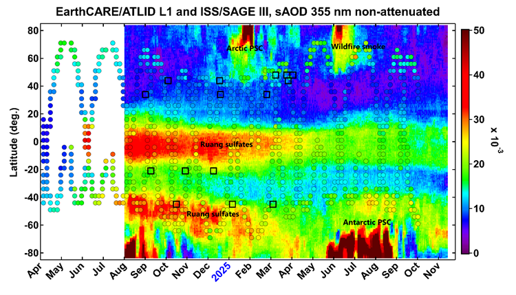
ATLID tracks stratospheric aerosols. This figure shows the evolution of stratospheric aerosol loading as a function of time and latitude from ATLID (colour shading) compared with ISS/SAGE III observations (color-coded circles) from April 2024 through November 2025. The locations of ATLID-collocated suborbital measurements are indicated by black squares. Since the beginning of its operation in July 2024, ATLID has been witness to various perturbations of stratospheric aerosol loading, including the Mount Ruang eruption in April 2024, Arctic and Antarctic polar stratospheric clouds (PSC) as well as the panboreal wildfire outbreak in May 2025.
© Khaykin, S., et al. Global transport of stratospheric aerosol produced by Ruang eruption from EarthCARE ATLID, limb-viewing satellites and ground-based lidar observations, Atmos. Chem. Phys., 26, 607–622, https://doi.org/10.5194/acp-26-607-2026, 2026. This work is distributed under the Creative Commons Attribution 4.0 License.
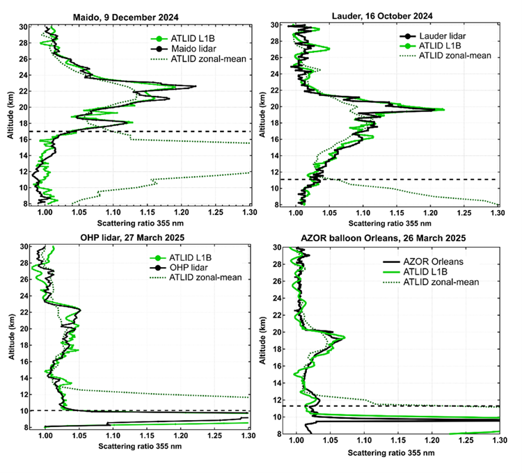
Intercomparison of ATLID and NDACC measurements. This figure shows the intercomparison of ATLID with NDACC ground-based lidar and balloon observation of aerosol backscatter at various locations: Maido (French tropical La Reunion island), Lauder (New Zealand), OHP (Haute Provence, France) and Orleans (France). Comparison of a ATLID with ground-based lidar and balloon observations of aerosol backscatter profiles show excellent agreement in the stratosphere and ATLID’s capacity to accurately resolve fine structures in aerosol vertical distribution.
© Khaykin, S., et al. Global transport of stratospheric aerosol produced by Ruang eruption from EarthCARE ATLID, limb-viewing satellites and ground-based lidar observations, Atmos. Chem. Phys., 26, 607–622, https://doi.org/10.5194/acp-26-607-2026, 2026. This work is distributed under the Creative Commons Attribution 4.0 License.
Tracking the plume across the globe: from the tropics to Antarctica
By combining ATLID’s vertical accuracy with other available information, the team was able to map the dispersion of sulfates from the eruption. The season favored efficient transport from the tropics to the Southern Hemisphere: the plume was quickly carried to southern latitudes, then spread over a large area. Over a period of several months, the particles reached the entire Southern Hemisphere and probably interacted with the dynamics of the Antarctic polar vortex.
International visibility and “unlimited” prospects
Beyond the scientific results, the study marks an important milestone for EarthCARE: it demonstrates ATLID’s ability to provide exceptional quality observations at a very early stage, which can be used for both research and instrumental validation. This success has been recognized by ESA’s communication channels and also relayed by the NDACC network.
The prospects are numerous: systematic analysis of volcanic eruptions, monitoring of major fire plumes, improved estimates of the radiative impact of aerosols, and future synergies with other European missions to better constrain atmospheric transport.
More
Reference
Khaykin, S., et al. (2026), Global transport of stratospheric aerosol produced by Ruang eruption from EarthCARE ATLID, limb-viewing satellites and ground-based lidar observations, Atmos. Chem. Phys., 26(1), 607-622. https://doi.org/10.5194/acp-26-607-2026
ESA Earth Online (success story)
https://earth.esa.int/eogateway/success-story/earthcare-reveals-global-impact-of-mount-ruang-eruption
IPSL – A successful launch fore the EarthCARE satellite
https://www.ipsl.fr/en/article/a-successful-launch-for-the-earthcare-satellite/