Lidar ATLID d’EarthCARE : premier test scientifique réussi grâce aux stations NDACC
L’éruption du volcan Ruang (Indonésie, avril 2024) a injecté des quantités importantes de sulfates jusque dans la stratosphère. Une équipe internationale, mené par des scientifiques de LATMOS présente la première étude exploitant les observations du lidar ATLID de la mission européenne EarthCARE à la fois pour la science et pour la calibration/validation. Ce travail, fondé notamment sur des mesures du réseau NDACC (dont les stations françaises OHP et OPAR), a été sélectionné comme mise en avant par l’ESA.
Une opportunité « parfaitement synchronisée »
EarthCARE est une mission européenne de nouvelle génération et le plus grand satellite de la famille des Earth Explorers de l’ESA consacrée à un objectif central des sciences du climat : mieux comprendre comment nuages et aérosols modifient le bilan radiatif de la Terre, et donc le climat. Peu après le lancement et alors que la mission entamait sa montée en puissance, l’éruption du Ruang a fourni un événement rare, intense et bien contraint — un véritable « cas d’école » pour éprouver les capacités des instruments, en particulier le lidar atmosphérique ATLID.
Le timing a joué un rôle clé : l’éruption s’est produite à un moment où l’on pouvait suivre, sur la durée, l’évolution d’un panache stratosphérique depuis sa source tropicale jusqu’à sa dispersion planétaire. Les observations ATLID ont montré que l’éruption a propulsé des particules (cendres et surtout aérosols sulfatés) jusqu’à environ 25 km d’altitude, conduisant à une augmentation marquée des aérosols stratosphériques. Au fil des mois, le signal s’est étendu bien au-delà des tropiques, jusqu’à une diffusion globale.
ATLID : un lidar spatial « hors norme »
ATLID (ATmospheric LIDar) est un lidar ultraviolet, conçu pour mesurer la distribution verticale des aérosols et des nuages fins. Il se distingue par l’utilisation d’une technologie de lidar à haute résolution spectrale, qui permet d’accéder directement à des paramètres essentiels pour le climat, notamment l’extinction des aérosols (c’est-à-dire la manière dont les particules atténuent la lumière en traversant l’atmosphère). Cette information est déterminante pour quantifier l’influence des aérosols sur le rayonnement et, in fine, sur le climat.
Des résultats marquants… et une validation robuste
L’étude constitue une première : c’est la première fois que les mesures d’ATLID sont exploitées de façon aussi complète pour une analyse scientifique stratosphérique, tout en servant d’étape structurante de cal/val (calibration/validation) pour une mission tout juste opérationnelle.
Pour s’assurer que les profils mesurés par ATLID sont fiables et correctement interprétés, l’équipe a réalisé des comparaisons systématiques avec des observations indépendantes. Un point fort du travail est son appui sur le réseau international NDACC (Network for the Detection of Atmospheric Composition Change), référence mondiale pour le suivi de la composition atmosphérique. Les comparaisons avec des lidars NDACC et des capteurs suborbitaux montrent un excellent accord dans la stratosphère, confirmant la précision d’ATLID et sa capacité à restituer finement la structure des couches d’aérosols.
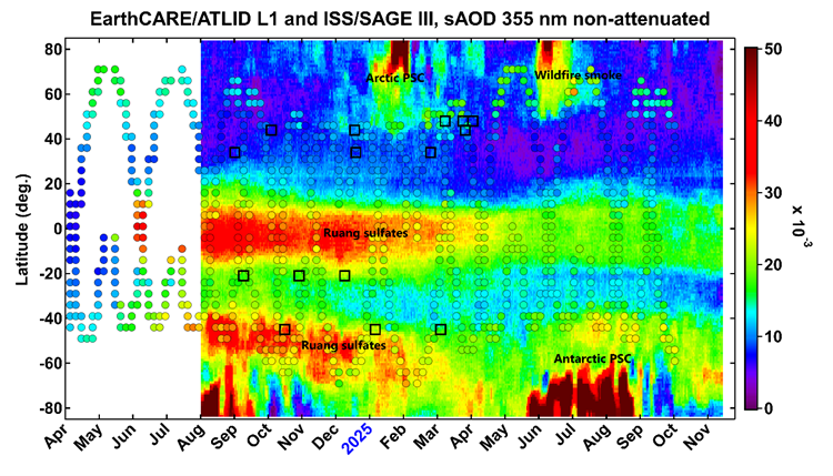
ATLID tracks stratospheric aerosols. This figure shows the evolution of stratospheric aerosol loading as a function of time and latitude from ATLID (colour shading) compared with ISS/SAGE III observations (color-coded circles) from April 2024 through November 2025. The locations of ATLID-collocated suborbital measurements are indicated by black squares. Since the beginning of its operation in July 2024, ATLID has been witness to various perturbations of stratospheric aerosol loading, including the Mount Ruang eruption in April 2024, Arctic and Antarctic polar stratospheric clouds (PSC) as well as the panboreal wildfire outbreak in May 2025.
© Khaykin, S., et al. Global transport of stratospheric aerosol produced by Ruang eruption from EarthCARE ATLID, limb-viewing satellites and ground-based lidar observations, Atmos. Chem. Phys., 26, 607–622, https://doi.org/10.5194/acp-26-607-2026, 2026. This work is distributed under the Creative Commons Attribution 4.0 License.
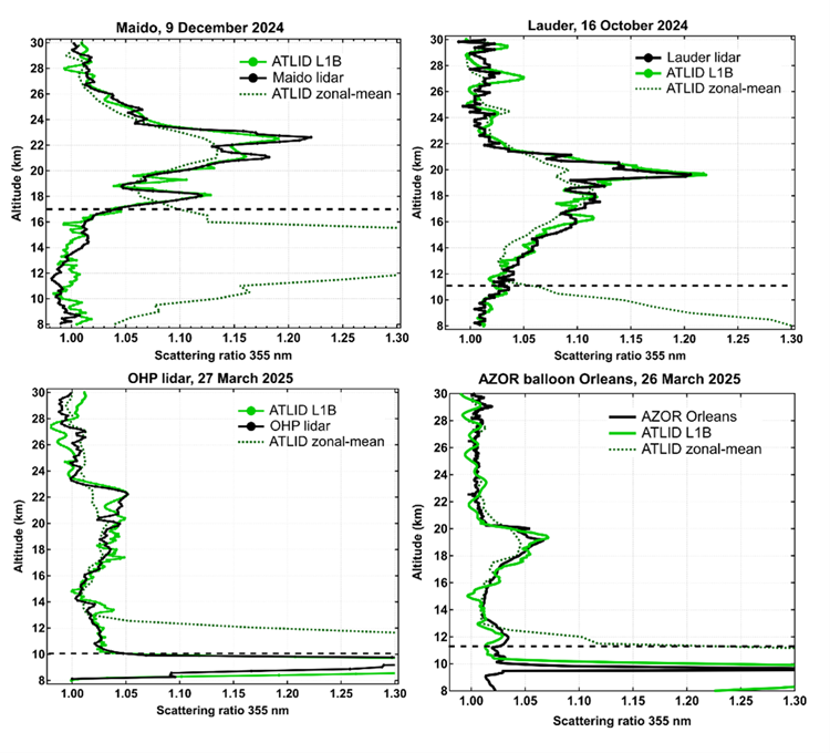
Intercomparison of ATLID and NDACC measurements. This figure shows the intercomparison of ATLID with NDACC ground-based lidar and balloon observation of aerosol backscatter at various locations: Maido (French tropical La Reunion island), Lauder (New Zealand), OHP (Haute Provence, France) and Orleans (France). Comparison of a ATLID with ground-based lidar and balloon observations of aerosol backscatter profiles show excellent agreement in the stratosphere and ATLID’s capacity to accurately resolve fine structures in aerosol vertical distribution.
© Khaykin, S., et al. Global transport of stratospheric aerosol produced by Ruang eruption from EarthCARE ATLID, limb-viewing satellites and ground-based lidar observations, Atmos. Chem. Phys., 26, 607–622, https://doi.org/10.5194/acp-26-607-2026, 2026. This work is distributed under the Creative Commons Attribution 4.0 License.
Suivre le panache à l’échelle du globe : des tropiques à l’Antarctique
En combinant la précision verticale d’ATLID à d’autres informations disponibles, l’équipe a pu cartographier la dispersion des sulfates issus de l’éruption. La saison a favorisé un transport efficace depuis les tropiques vers l’hémisphère Sud : le panache a été rapidement entraîné vers les latitudes australes, puis s’est étendu à grande échelle. À l’échelle de plusieurs mois, les particules ont gagné l’ensemble de l’hémisphère Sud et ont probablement interagi avec la dynamique du vortex polaire antarctique.
Une visibilité internationale et des perspectives « sans limite »
Au-delà du résultat scientifique, l’étude marque un jalon important pour EarthCARE : elle démontre la capacité d’ATLID à fournir très tôt des observations d’une qualité exceptionnelle, utilisables à la fois pour la recherche et pour la validation instrumentale. Cette réussite a été reconnue par une mise en avant sur les canaux de communication de l’ESA, et relayée également par le réseau NDACC.
Les perspectives sont nombreuses : analyses systématiques d’éruptions volcaniques, suivi des panaches d’incendies majeurs, amélioration des estimations d’impact radiatif des aérosols, et synergies à venir avec d’autres missions européennes pour mieux contraindre le transport atmosphérique.
Pour en savoir plus
Référence
Khaykin, S., et al. (2026), Global transport of stratospheric aerosol produced by Ruang eruption from EarthCARE ATLID, limb-viewing satellites and ground-based lidar observations, Atmos. Chem. Phys., 26(1), 607-622. https://doi.org/10.5194/acp-26-607-2026
ESA Earth Online (success story)
https://earth.esa.int/eogateway/success-story/earthcare-reveals-global-impact-of-mount-ruang-eruption
IPSL – Lancement réussi d’EarthCARE
https://www.ipsl.fr/en/article/a-successful-launch-for-the-earthcare-satellite/